Cloud Architecture
<- Return to all blogs
-
(Re)Making Cirrus: Reflections on five years spent building an open-source data orchestrator
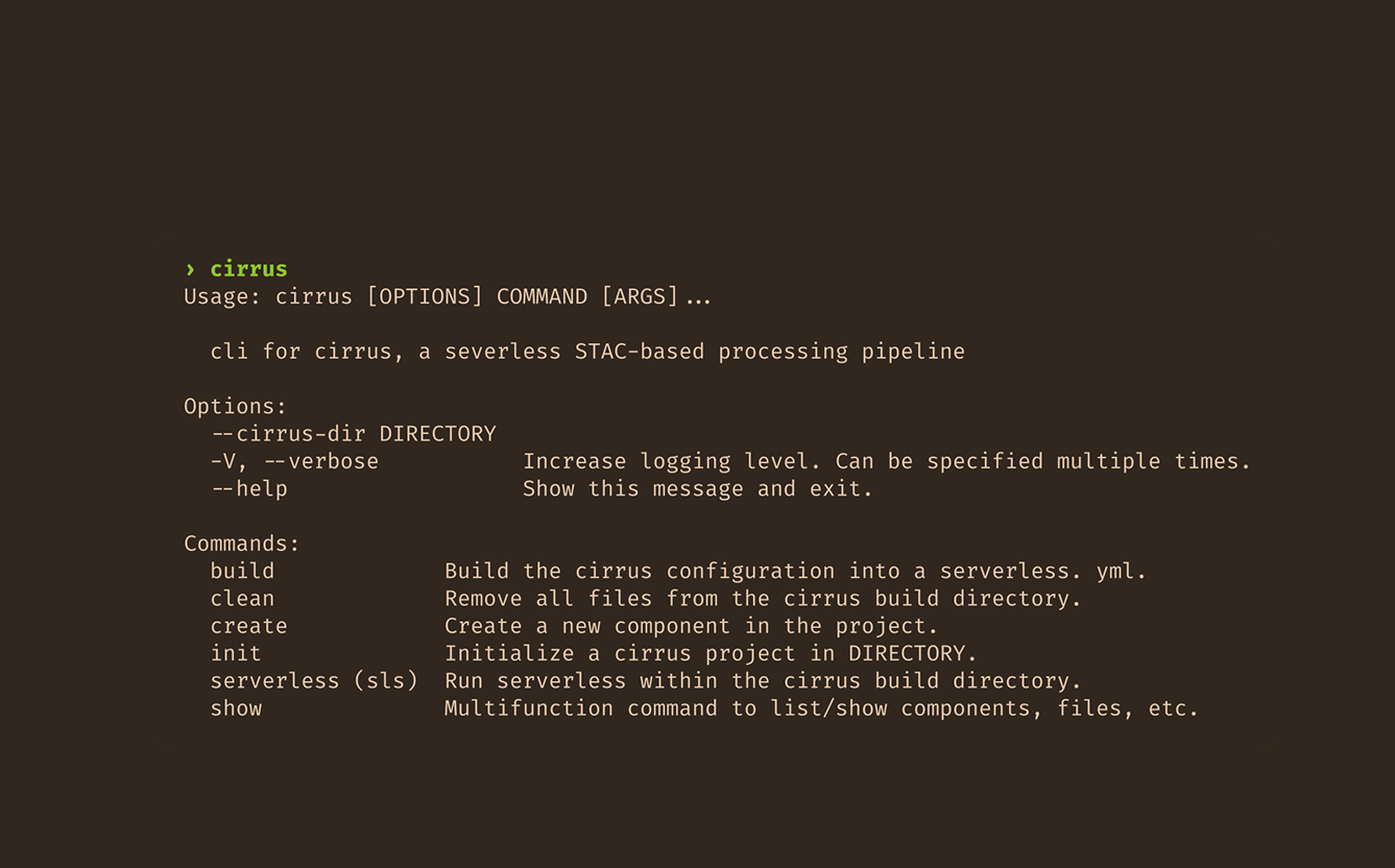
This post is based on the author’s talk (Re)Making Cirrus: Five Years Building a Data Orchestration Framework, presented at FOSS4 NA 2025 and FOSS4G 2025. We’ve remade Cirrus at least three times. Maybe four, depending on how you count. Cirrus, a data orchestration framework we develop and use here at Element 84, recently celebrated its…
-
(Re)Making Cirrus: Reflections on five years spent building an open-source data orchestrator
This post is based on the author’s talk (Re)Making Cirrus: Five Years Building a Data Orchestration Framework, presented at FOSS4 NA 2025 and FOSS4G 2025. We’ve remade Cirrus at least three times. Maybe four, depending on how you count. Cirrus, a data orchestration framework we develop and use here at Element 84, recently celebrated its…
-
STAPI Sprint #4: Interoperability for Satellite Data Ordering
During our most recent STAPI sprint we brought together attendees from across the geospatial industry to discuss interoperability for satellite data ordering.

-
Building a queryable Earth with vision-language foundation models
We take a close look at two such remarkable VLMs that have come out in the past few months and, using these models, we build a prototype “queryable Earth” functionality that allows retrieving images along with their geolocations using text queries over a large geographical area.

-
Using GDAL with EMR-serverless for large-scale data processing
In this blog, we discuss the history of modern big data and outline how we use GDAL-EMR-serverless for large-scale data processing.

-
Introducing Earth Search Console: An AWS Open Data Exploration UI
In this blog, we’ll detail how Earth Search Console leverages FilmDrop, and what Console components we are most excited about.

-
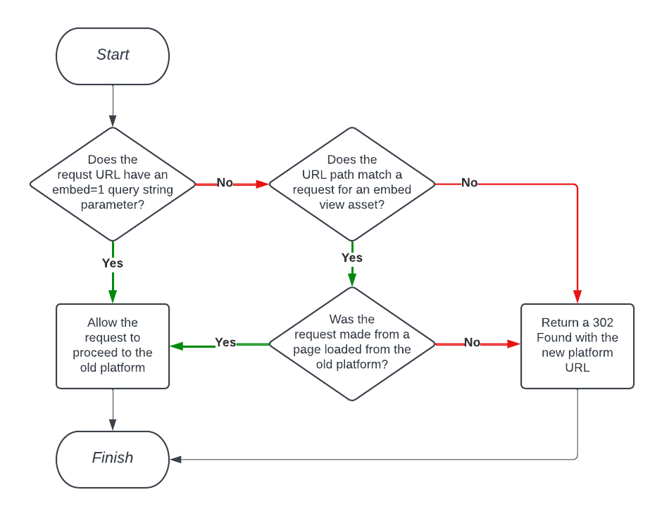
Using Amazon CloudFront Functions to Facilitate Smooth Project Transitions with Conditional Redirects
In this blog, we detail our experience making this project transition possible for our client by implementing conditional redirects via Amazon CloudFront functions.
-
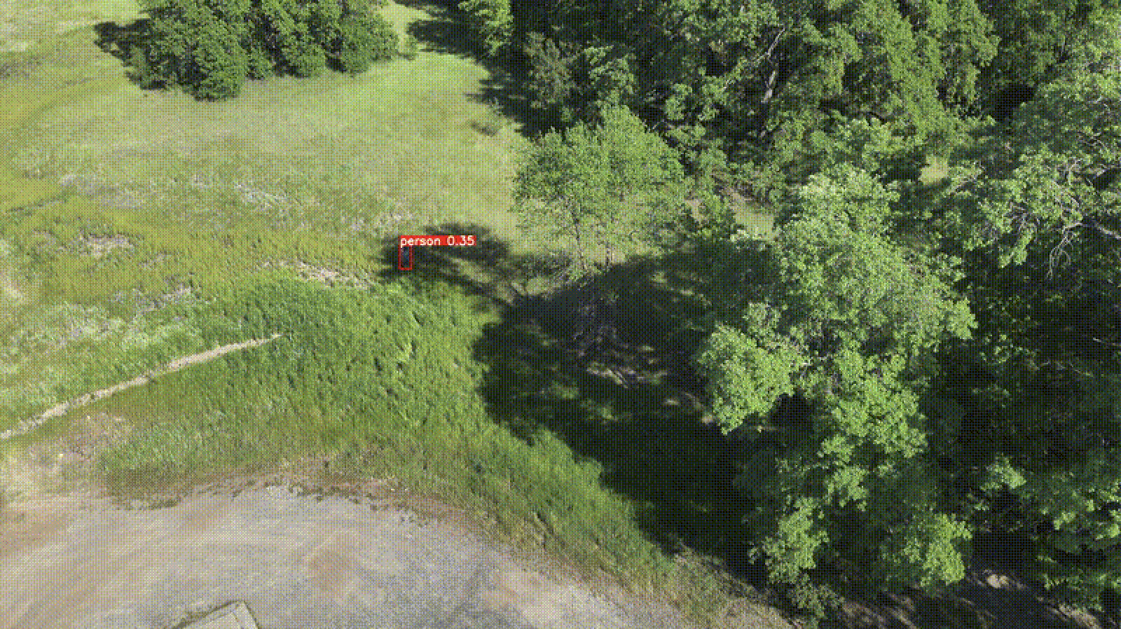
Edge Processing of Drone Data for Search and Rescue using Open Source Tooling on an AWS Snowcone
Element 84 has developed near real-time edge processing of drone and aerial imagery for human identification that leverages machine learning and AWS Snowcone edge capabilities during austere operations for search and rescue applications.
-
AWS re:Invent 2022 Mega Recap
This month our geospatial team traveled to Las Vegas to attend AWS re:Invent and talk about FilmDrop—our cloud-native, geospatial processing suite. Over the course of the week, we had a chance to meet tons of great people and spend time in talks and labs learning as much as we could. We’ve put together a mega…

-
Tasking Sprint
Two weeks ago, right before SatSummit, we hosted a “Satellite Tasking API Sprint” at our office in Alexandria. The goal was to initiate a conversation around standardizing how users submit tasking requests to data providers. The companies attending, made up of data providers, analytics users, and developers, represented a wide and deep knowledge base around…

-
A Software Engineer’s First Experience with Geospatial: Data, Tooling, and STAC
About a year ago, I started on a new project at Element 84 working with geospatial imagery. In this blog post, I will document some things I learned on my journey. My hope is these lessons learned will help encourage more generalist software engineers to start experimenting with geospatial data and tooling. I had never…