Initially inspired by the ThoughtWorks Tech Radar, we have been thinking about creating a geospatial tech radar for almost a decade. Back in 2014, we published our first take on a geospatial version on our blog. It proved to be a successful post, and we loved seeing the community benefit from the information we shared. Ahead of this year’s FOSS4G North America gathering, we’re rolling out a 2023 edition of our Geospatial Tech Radar idea, which we plan to update annually to track what’s up-and-coming in geospatial techniques, standards, data, and tools/platforms.
Why make a Geospatial Tech Radar?
Although the idea of a geospatial tech radar is unique, our inspiration for this project stems directly from the ThoughtWorks Tech Radar. In the same way that the facilitators of the radar at ThoughtWorks aim to catalyze the spread of information within the tech community, we feel that the idea of a geospatial tech radar is aligned with our dedication to developing and supporting an open knowledge ecosystem for geospatial technology. Element 84 is much smaller than ThoughtWorks, but our software engineering, UX, DevOps, and machine learning teams comprise one of the larger geospatial professional services firms and represent decades of experience within this space. As leaders on open standards like STAC and STAT, managers and contributors to several open source projects (stac-utils, Raster Vision, Cirrus, GeoTrellis, etc.), and teams that support an array of government, commercial, and nonprofit customers, we are exposed to a significant cross section of geospatial technology, and we believe we are in a unique position to contribute to the ever-evolving conversation around the tools and techniques used in our industry. Further, our commitment to open technology is rooted in a desire to work with our geospatial peers in service of the greatest possible impact.
What makes our Geospatial Radar different?
When we set out to develop our take on the tech radar concept, we made several departures from the ThoughtWorks Tech Radar in terms of both the organization and the graphical presentation of the information.
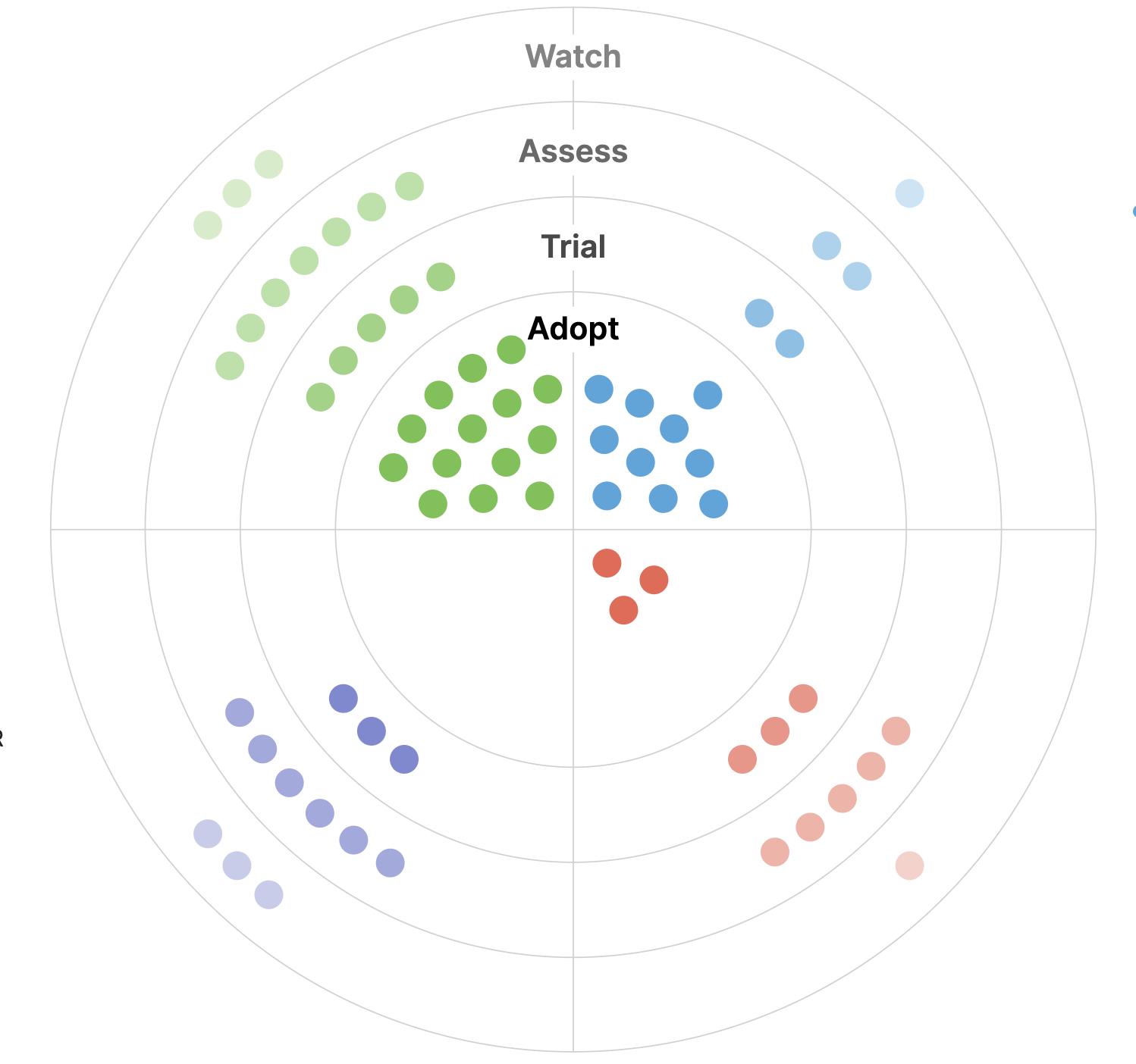
If you are familiar with the Thoughtworks example, you may know that each technology entry is known as a “blip” and the blips are organized into quadrants (categories) and rings (levels of confidence in the technology). In the Thoughtworks version, the four quadrants are Platforms, Languages, Tools, and Techniques. In order to better align our commentary with our experience and expertise, we made the decision to replace Platforms and Languages with two new categories: Data and Standards. We also combined Tools with Platforms as they felt difficult to distinguish. Data sources, both commercial and open, are a key element of working with geospatial technology. And we have been leaders in both developing new standards and specifications and leveraging standards in the work we do for our customers, so the Standards category made sense on those grounds.
Second, we made some changes to the “rings”. The rings are nested such that the newest technology often starts in an outer “Assess” ring and then moves inward to “Trial” and then “Adopt”. Thoughtworks also has an outer ring called “Hold” that is used to designate technologies with which they have developed experience, but they recommend against using. When we developed our draft list, we had very few blips that fell into the Hold category; I think we are generally more interested in highlighting what’s new and interesting or where significant changes have taken place than in warning people off things. Instead of “Hold”, we’ve made the outermost ring “Watch” for technologies that are approaching but may not yet exist. We felt this was both a better fit for the radar metaphor and aligned with our interest in data and tooling that we can foresee will have an impact but with which we cannot yet develop real world experience.
The Thoughtworks radar also has some additional elements. Because it’s released every six months, they include some directionality for the blips, indicating if a technology is “moving” or maturing toward the Adopt status. Since this release is our first radar since 2014, we did not add this directional information. However, if we are able to turn this into an annual endeavor, we may add this to future editions. We also removed all numbers from our radar to ensure it is clear to readers that we are not ranking elements against each other. Rather, anything in the same bucket is equal.
Finally, we asked our UX team to take a critical eye to the graphic design and presentation of the radar. In addition to removing the numbers, we have added shading to indicate the distance of a blip from the innermost Adopt ring. In the online interactive version, we worked to make it possible for users to stay in one place when reviewing the detailed info rather than jumping to a different section of the page. In addition to the shift in viewing location, we also made the names of everything viewable at once. Finally, in the PDF version, we have changed from the circular radar presentation to a gridded version at the top of each section.
How did selection for our Geospatial Tech Radar work?
Our Geospatial Tech Radar is not intended to be a comprehensive ranking of every concept and product in the geospatial technology space. Similar to ThoughtWorks, we made a deliberate decision to make our Geospatial Tech Radar an opinionated one based on actual experience, rather than trying to be a comprehensive overview of everything in the ecosystem. When you read, we’re pretty confident, you’ll have a lot of thoughts along the lines of “What about _____? Why wasn’t XYZ technology included?” Essentially, the answer is that either a) we don’t feel like we have enough experience with it to have a strongly held opinion; or b) it’s so well accepted that it’s not new information or nothing has changed in the recent past that we believe it’s worth highlighting. For example, you might think that PostGIS is a glaring omission. We have a lot of experience with it, and it’s our default database for vector geospatial data, but we believe its capabilities are so well established that we don’t think we have a lot to say about it. The same goes for core tools like GDAL or PROJ. Finally, we applied some clear biases in favor of open source, open standards, and open data; we’re fundamentally in the tank for cultivating an open knowledge ecosystem for doing geospatial work.
In terms of our process, we gathered our key technology leaders in the organization to outline the concept and solicit input. We then compiled a list of technologies with which we had experience and we felt we might have something useful, interesting, or otherwise compelling to say.i Once our list of blips was solidified, engineering and design leads took to writing their thoughts on each one. By pulling direct insight from all sides of the organization, we were able to compose a snapshot of each blip from folks who interact with these principles and products on a daily basis.
What’s next for the Geospatial Tech Radar?
In a future version of the Geospatial Radar, I’d like to make several changes. First, I’m pretty confident that we probably have some omissions that simply didn’t occur to us on this first version. Second, we are interested in digging into the “direction of travel” question outlined above. Third, I’d like to be able to articulate some general themes that we can extract from what we have chosen to highlight.
If you’re stumbling on this post soon after its publication, you can learn more about the process and inspiration behind our radar at FOSS4G-NA 2023 in Baltimore October 23-25. At this point, we’re excited to get the word about this idea, and we’re excited to start brainstorming for next year’s edition. Check out the interactive radar or download it as a PDF. Also, we would love to hear from you! Get in touch with our team if you’re interested in learning more about the radar, or about any of the specific elements we cover in the radar itself!