What is the geospatial tech radar?
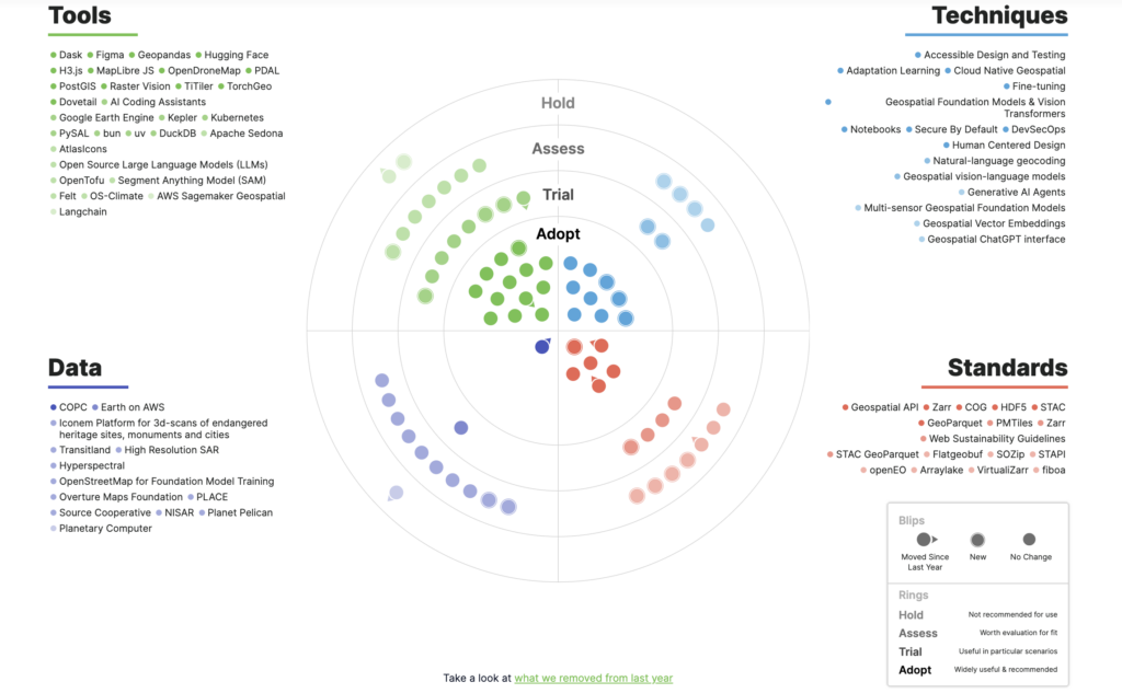
Last year, we introduced our geospatial technology radar as a resource for the geospatial community. Based on a more general technology radar produced by Thoughtworks, our radar is designed to share our thoughts and feedback on emerging and impactful tools, standards, techniques, and data in the geospatial field. We discussed the inspiration behind the radar at greater length in a blog post when it was released, and we shared highlights from the first edition during last year’s FOSS4G NA conference in Baltimore. Ultimately, the reception for the radar was extremely positive and we are excited to roll out the second edition at this year’s FOSS4G NA conference.В
How did we approach the radar differently this year?
Because our geospatial technology radar is intended to serve as a resource for the community, yearly improvement is a crucial component of the process. This year, we made a few primary changes to both the overall design and to the content included to reflect both internal and external feedback we received after rolling out the 2023 radar.В
Changes to the content
- Opened submissions to external contributors
Perhaps most significantly, this year’s radar features contributions from external contributors! Last year, the content for the radar was informed exclusively by submissions from our team here at Element 84. Although we have a diverse team with broad perspectives, for this year’s radar it was important to us to open submissions to the geospatial community to ensure that the radar is truly a resource that represents and supports the community as a whole. This year we received submissions from 6 external contributors, and we look forward to increasing that number for next year’s radar.В
- Retired the “watch” category in favor of “hold”В
As mentioned earlier in this blog, our radar is inspired by the Thoughtworks tech radar. Although this is the case, there are several major decisions we made with our radar that deviate from the Thoughtworks layout. In last year’s radar, one of these decisions was the choice to implement a “watch” category rather than a “hold” category. This decision was discussed in last year’s roll-out blog, and made sense to use because we were, “generally more interested in highlighting what’s new and interesting or where significant changes have taken place than in warning people off things.” Although our goal remains to highlight new and interesting developments in the community, this year it has become clear that, in order to demonstrate shifts in these developments from year to year, there are notable instances where it is helpful to recommend a “hold” categorization.В
- Removed certain elements, and kept others the same
В Since this was the second year of the radar, there were a few key elements that we needed to set a new precedent for. Namely, it became clear that some blips would need to be removed. For the most part, this differentiation occurred when we realized that the blip was no longer relevant to our interests within the community, so we no longer had meaningful input on that particular subject.В
Tangentially, there are a number of blips that remained static over the course of the past year. For the most part, the geospatial field is extremely quickly moving. That being said, there is a large amount of work that is in progress, and takes awhile to become fully realized. When there were blips that our team decided not to move from their relative position on last year’s radar that we don’t have an update to, we note that in the content – but we chose to keep them around due to their current impact and potential for further greatness.В В В
Changes to the design
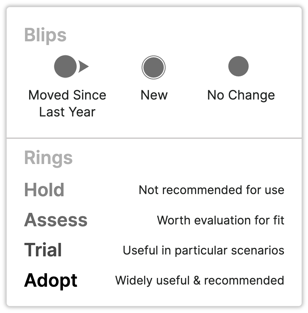
- Added design elements to represent ring changesВ
Because this year’s radar is only the second iteration, we ran into a few “firsts” while putting together the updated version. Notably, this was the first time we had to contend with blips shifting from one ring to another. Last year, all of the blips were new to the radar. In contrast, this edition includes blips shifting up and down the rings, as well as blips being added or removed entirely.В
In order to clearly demonstrate these shifts (in line with the ThoughtWorks radar), we added symbols around the blip icons on the “target” diagram as well as a corresponding key. In the target format, when blips move closer to the center toward adoption they receive an arrow pointing toward the center. When they move away from the center toward hold, blips receive an arrow pointing toward the outside of the circles. When a blip is added there is a ring around it to show that it is new, and when a blip stays the same from the previous year there is neither a circle or an arrow shown with it.В
- Included removed blips, why we removed, and links to previous editions of the radar
On the radar page this year we included a few additional features in the broader design to improve clarity. Although we did not list specific explanations for each removed blip, we felt that it was important to show the specific elements that were removed and to include a general explanation for some potential factors we kept in mind while considering blip removal. We also included a link to the previous tech radar near the bottom of the page.В
Blips we removed from the radar
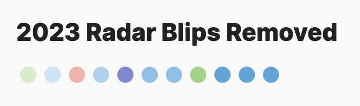
Once we decided that removing certain blips would be necessary, we worked to determine a general criteria to guide us in making the decision. At the end of the day, the reasons were varied:
- Blips were too general. In last year’s radar we included “data lakes” as a concept, but this year we decided to cover blips that involve data lakes while being more specific.
- In some cases, blips were too specific. We decided to swap GitHub CoPilot for Generative AI Coding Assistants in this edition as AI coding assistants have experienced tremendous growth of a tool category in the past year and Element 84 is working to pilot tools in this category (and you should too!).
- Others didn’t have a champion at the company. Because we want the radar to reflect what we hold an opinion on, it’s important to us that we are speaking to concepts and ideas that we have an understanding of and experience with.
The rise of AI as demonstrated by the geospatial tech radar
Over the past year, the geospatial field has shifted dramatically due to massive growth in AI and LLMs, and our radar this year reflects that impact. In last year’s radar we included AI-related blips, but, even so, the quantity of AI-related blips has almost doubled in this edition. As expected, AI plays a large part in the trends we’re seeing between this and last year.
We’ve seen a massive increase in Generative AI tooling and LLM integrations, and with this increase in tooling we made the decision to broaden the scope of some blips. Through increasing the scope, we are now able to consider entire categories of tooling as we pilot some specific tools within those categories. A few examples of this in action include our decision to feature LLMs broadly instead of focusing solely on ChatGPT, or to pivot from GitHub CoPilot (as we did last year) to AI coding assistants in this year’s radar.
Foundation models
Throughout this year, we’ve noticed a general shift toward the use of open foundation models rather than tooling to build and train personal models. Now, through our radar, it is interesting to consider how we can lean into this to leverage existing models. At the time of this blog post, Hugging Face has over 900,000 models available, and this number continues to rise.
Element 84 is exploring ways to lean into this and leverage existing models for geospatial applications. A few interesting examples include:
- Agents connecting LLMs to external tooling, integrating geospatial-specific features and capabilities with natural language.
- Natural language geocoding: converting a spatial description of an area to a polygon that can be used for search.
- Geospatial vector embeddings: splitting images into smaller “chips” that can be analyzed by a vision model and then used for searching, change detection, and more.
AI brings exciting solutions and evolution to our industry as well as new and bigger problems to solve. For example, when exploring vector embeddings, we have to explore how to store the massive amount of embeddings, which leads us towards GeoParquet as a potential solution. Both GeoParquet and Zarr have had exciting new developments over the last year as well as additional tools popping up. As the amount of data and metadata increases, we need to look at new ways to store and search that data. We’re excited to assess and trial some new solutions in the coming year and report back next year!
What’s next with our geospatial technology radar?
Like last year, one of the best parts of this radar is its potential to continue to evolve and grow. We look forward to continued design and content development over the next year, and it is exciting to consider the technology trends that we will be able to highlight in our next edition.
We are thrilled to have this year’s geospatial tech radar out in the community, and we rely on your support to help us share it around! Get in touch with our team to let us know what you think, and start to brainstorm your ideas for next year’s version.В
Radar Contributors
Content: Adeel Hassan, Andrew Pawloski, Catherine Oldershaw, Jason Gilman, Julia Signell, Kevin Mentzer, Lauren Frederick, Matt Hanson, Sara Mack, Terence Tuhinanshu
External Contributors: Drew Dara-Abrams, Interline Technologies; Howard Butler, Hobu, Inc; Jonathan Chemla, Iconem; Matthias Mohr; William Lyon
Design: Catherine Oldershaw, Philipp Schmidt
Development: Brian Andres