
Wildfires in the U.S. are becoming larger and more destructive due to climate change, a century of forest mismanagement, and increasingly more construction in fire-prone areas. Counterintuitively, most people tend to under-estimate their own risk. For instance, a Forest Service survey in Jackson, WY, found that only 10% of homeowners rated their wildfire risk as high or extreme, while experts rated 46% of the same homes as high or extreme risk. According to Headwaters Economics, over 115 million people—more than one-third of the U.S. population—live in counties with high wildfire risk.
The importance of sharing wildfire risk data
With so many people living in high-risk areas, making wildfire risk data available for free and in a way that’s easy to understand and access is becoming more and more important. Wildfirerisk.org, a free tool created by the USDA Forest Service and Headwaters Economics, does just that. The tool was created under the direction of Congress and is designed to help the general public and community leaders, such as elected officials, community planners, and fire managers, understand wildfire risk across a state, region, or county and prioritize actions to mitigate risk.
The Wildfire Risk to Communities team partnered with Element 84 to make this data as easy to understand and accessible as possible. The Explore Risk web app draws on the latest advances in wildfire simulation modeling, incorporating weather data, vegetation and fuel information, and data about buildings and housing units. The app analyzes risk to homes, wildfire likelihood, and types of wildfire exposure (e.g. direct flames from nearby fires or indirect exposure through burning embers flying from a fire miles away) for the entire US.
On wildfirerisk.org, users can find any community, tribal area, county, or state in the nation and explore interactive maps and other information to help them understand which areas are most at risk. Users can overlay wildfire risk with data on vulnerable populations in order to direct outreach and risk reduction efforts towards those most at risk. The tool then directs users to tailored resources designed to reduce risk such as ignition-resistant building materials, land-use planning information, and federal wildfire resilience grant application guidance.
Wildfirerisk.com over time
Since first launching the tool in 2020, our team at Element 84 continues to work with the Wildfire Risk to Communities team to add new features and make improvements based on expert feedback, rounds of usability testing, and usage data. We recently rolled out a major update to the tool complete with the latest wildfire risk data, a new accessibility-focussed design system, and an updated Risk Reduction Zones page.
Implementing usability testing for recent updates
As part of the latest iteration of this project we conducted usability testing to ensure that our goals were grounded in real user needs for the latest phase.
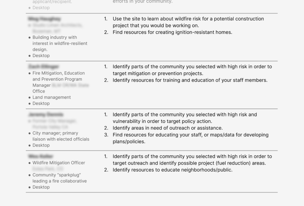
Although the tool is intended for community leaders, it should still speak to folks with a range of backgrounds. Some key audiences we prioritized throughout this work include:
- Planners and adaptation professionals: where should they be focussing time and energy, considering risk and vulnerable populations?
- Semi-experts like citizen groups or construction industry: how can they discover resources for wildfire-resistant construction and identify priority areas for outreach or fuel treatments?
- Homeowners and media: how can they maintain an understanding of the relative risk in their community and learn about potential actions they might take to secure additional safety for their homes and neighborhoods?
To learn more about these groups and how they interact with the site, our team conducted seven one hour usability tests with representatives of each. The interviews allowed time for task observation and collected open-ended feedback from participants while giving our team an opportunity to demonstrate new concepts and proposed features within the program. We ran a system usability score survey with each participant, and gathered input on specific verbiage used throughout the application.
After completing each interview our team analyzed the results using Dovetail, Figjam, and Google Docs, and then grouped our findings into action areas, which we then prioritized with the client.
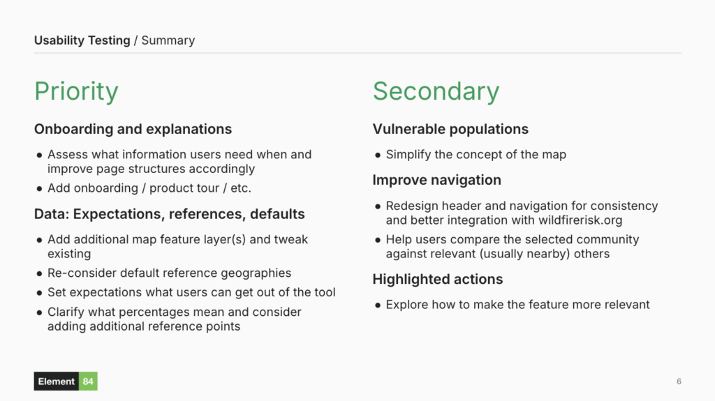
Overall, our user interviews revealed a general consensus surrounding a few usability issues, but they reflected a broader variation in understanding of the content between wildfire experts and non-experts.
The latest from wildfirerisk.org
After conducting the usability tests detailed above, we were able to implement a variety of changes based on our findings and the participant feedback we received. At the end of the day, our team implemented a new design system, improved clarity of language across the application, polished elements of the program’s navigation, and implemented updates to the basemap, Vulnerable Populations map, and Risk Reduction Zones sections.
Over its entire lifetime, the site has been viewed over 2 million times and users have searched for over 15,000 locations. Since releasing these updates in December 2024, the site has been viewed more than 460 thousand times, a 370% increase over the previous year. In January 2025, the Los Angeles area in California experienced a series of devastating wildfires. During this time, there were more than 260 thousand views to the site, which reflects a 559% increase from January 2024. During these wildfire events, Los Angeles and LA County were among the most searched locations, with more than 2,000 searches each. These results demonstrate the need for wildfire risk information and the impact that wildfirerisk.org can have for communities in high-risk areas experiencing devastating wildfires.
We are looking forward to continued collaboration with the Wildfire Risk to Communities team to increase the application’s impact even more with future iterations. If you have any questions about this project, or if you’d like to learn more about how these techniques can help solve critical problems in your own work, we’d love to hear from you!