All blog posts
<- View categories
-
Solving Unicode Problems in Python 2.7
We discuss three steps you can take to begin thinking about strings and unicode the right way.
-
Solving Unicode Problems in Python 2.7
We discuss three steps you can take to begin thinking about strings and unicode the right way.
-
Technology Radar 2014
We’re releasing our first Technology Radar. A Technology Radar, pioneered by ThoughtWorks, is a list of the techniques, tools, platforms, languages, and frameworks divided into recommendation levels: Adopt, Trial, Assess and Hold. It’s mostly a list of things we find useful and interesting.
-
Exporting Django Querysets to CSV
In this blog, we discuss our experience with exporting Django querysets directly to HTTP responses with CSVs attached.
-
GeoTrellis 0.9 is out
The GeoTrellis team is very excited to announce the availability of GeoTrellis 0.9 (codename “Avalon”), a significant new release that is a big step forward towards our goal of a general purpose, high-performance raster geoprocessing library and runtime designed to perform and scale for the web.

-
GeoTrellis 0.9 Released
After several release candidates and getting the hang of a new review and release process as part of GeoTrellis’ journey to be a LocationTech-incubated project, we’re proud to announce that GeoTrellis 0.9 – codenamed “Avalon” – is officially released!
-
GeoTrellis Software Framework Submitted to the Eclipse Foundation
We announce that we’ve submitted GeoTrellis, a high-performance geospatial data processing framework, to LocationTech, a new working group at the Eclipse Foundation focused on geospatial open-source projects.
-
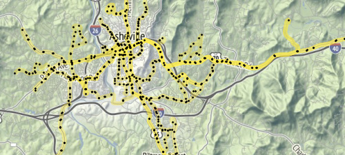
What is GTFS?
In this blog we describe GTFS, the General Transit Feed Specification and outline some of our work with it.
-
Update: Comparing Sprite Kit Physics and Direct Box2D Simulation Times
In a previous post I compared Sprite Kit physics to using Box2D directly. In that comparison I used frames per second as measured by Instruments, but it is useful to look at straight simulation time (ignoring rendering time), which I present here.
-
Comparing Sprite Kit Physics to Direct Box2D
I have recently done some work with Sprite Kit and have made some observations regarding the built in physics simulation capabilities. Based on these observations, I have decied to take a closer look at Sprite Kit physics, specifically comparing it to using Box2D directly.
-
Running Parameterized Tests in iOS
In this blog we describe how to run parameterized tests in iOS.