Author: Azavea
<- Return to all blogs
-

Raster Versus Vector Visualization
In this blog, we compare raster and vector visualization, and describe our work with Girlstart and City Harvest, two east-coast-based non-profits.
-
Raster Versus Vector Visualization
In this blog, we compare raster and vector visualization, and describe our work with Girlstart and City Harvest, two east-coast-based non-profits.
-
GeoTrellis Selected for Three Google Summer of Code 2014 Projects
GeoTrellis, our open-source framework, is a recipient of three Google Summer of Code fellowships, a global competitive program that offers students stipends to write code for open source projects.
-
Which Candidates for Governor of Pennsylvania Support Open Data?
In this post we outline which candidates for Governor of Pennsylvania support open data principles.

-
OpenDataPhilly is getting an upgrade and more funding
Learn more about the latest funding updates to OpenDataPhilly.
-
SBIR Grant Obtained to Develop Web-based, Hyper Local Climate Impact Assessment Modeling Service
Learn more about our SBIR grant and our plans to develop a web-based, hyper local climate impact assessment modeling service.
-
Grant Awarded to Build an Interactive Climate Modeling Service for Local Governments
We describe the plans we have to build an interactive climate modeling service for local governments in partnership with The Nature Conservancy.
-
GeoTrellis 0.9 Released
After several release candidates and getting the hang of a new review and release process as part of GeoTrellis’ journey to be a LocationTech-incubated project, we’re proud to announce that GeoTrellis 0.9 – codenamed “Avalon” – is officially released!
-
GeoTrellis Software Framework Submitted to the Eclipse Foundation
We announce that we’ve submitted GeoTrellis, a high-performance geospatial data processing framework, to LocationTech, a new working group at the Eclipse Foundation focused on geospatial open-source projects.
-
What is GTFS?
In this blog we describe GTFS, the General Transit Feed Specification and outline some of our work with it.
-
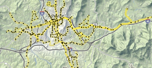
Calculating Travelsheds and Transit Accessibility with GeoTrellis Transit
In this blog, we discuss our experience calculating travelsheds and transit accessibility using GeoTrellis Transit.